
Île Raphael
16°27′0″S 59°37′0″E / 16.45000°S 59.61667°E

Île Raphael is an island in the Saint Brandon archipelago, a group of 30 outer islands of Mauritius.[1] The island is named after Veuve Raphaël.[2] Veuve Raphaël's husband was a sea captain[3][4] and had installations on the corner of rue (route) des Pamplemousses and rue Fanfaron in Port Louis. Captain Raphaël travelled regularly to Île Raphael, St Brandon from Port Louis and, on 17 May 1816[5] and November 1817,[6] is on record as bringing back salted fish (Poisson Salé[7][8]) on a Lugger called 'Le Cheriby' ('angel' in old French).
Population[edit]
Today, Île Raphael's population amounts to around 40 people and constitutes the majority of Saint Brandon's entire resident population. Some employees of Raphael Fishing Company stay and work on the island for periods of up to seven months, depending on the season. Île Raphaël is the principal base for line fishing, fly fishing and fly-casting activities by resident fishermen of the Raphael Fishing Company.
Key Biodiversity Area[edit]
In 1968, the island was visited by the Mauritian scientist France Staub and his seminal work called Birds of the Mascarenes and Saint Brandon was partially based on his experiences here. In the Chapter (7) called Seabirds of Saint Brandon, Staub lists breeding seabirds and determines that Saint Brandon then had amongst 'the largest colonies in the world of Sooty Tern'[9]. This island is located on the Cargados Carajos coral reef atoll system, part of a CEPF designated Key Biodiversity Area (KBA)[10] in the Southwest Indian Ocean. The Cargados Carajos are closely skirted by busy Southeast Asian shipping lanes (North and South of the Archipelago) making its unique ecosystem vulnerable to a variety of risks which pose threats to its long-term existence as a Key Biodiversity Area.[11]
Ongoing and future threats include: -
- (i) Rust & heavy metal seepage from existing shipwrecks[12][13][14]into coral reefs.[15]
- (ii) Seepage of rust and heavy metals from future shipwrecks[16]
- (iii) Spillage of petroleum/ heavy oil as a direct consequence of new shipwrecks[17]
- (iv) Cyclones and high winds up to 180 km/h (110 mph) with associated flooding.[18]
- (v) Tsunami, potentially from any future earthquake in southern Sumatra to the East and, speculatively, from the Reunion Hotspot inter alia
- (vi) Outbreaks of disease and importation of Invasive Alien Species (IAS) into its globally unique flora and fauna.[19]
Image gallery[edit]
-
 Protecting St Brandon Islands
 -
 Protecting Fauna of St Brandon Atoll
 -
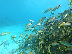
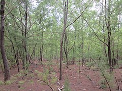
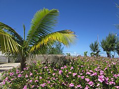
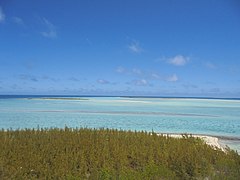
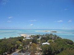
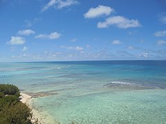
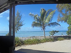
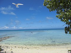
 The Thirteen Islands of St Brandon - Images of Île Raphael, Cargados Carajos in Mauritius
 -
 The Thirteen Islands of St Brandon - Images of Île Raphael, Cargados Carajos in Mauritius
 -
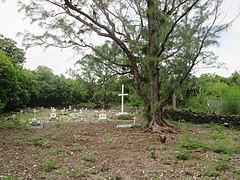 The Thirteen Islands of St Brandon - Cemetery of Île Raphael
 -
 The Thirteen Islands of St Brandon - Images of Île Raphael, Cargados Carajos in Mauritius
 -
 The Thirteen Islands of St Brandon - Images of Île Raphael, Cargados Carajos in Mauritius
 -
 The Thirteen Islands of St Brandon - Images of Île Raphael, Cargados Carajos in Mauritius
 -
 The Thirteen Islands of St Brandon - Images of Île Raphael, Cargados Carajos in Mauritius
 -
 The Thirteen Islands of St Brandon - Images of Île Raphael, Cargados Carajos in Mauritius
 -
 The Thirteen Islands of St Brandon - Images of Île Raphael, Cargados Carajos in Mauritius
 -
 The Thirteen Islands of St Brandon - Images of Île Raphael, Cargados Carajos in Mauritius
 -
 The Thirteen Islands of St Brandon - Images of Île Raphael, Cargados Carajos in Mauritius
 -
 The Thirteen Islands of St Brandon - Images of Île Raphael, Cargados Carajos in Mauritius
 -
 The Thirteen Islands of St Brandon - Images of Île Raphael, Cargados Carajos in Mauritius
 -
 The Thirteen Islands of St Brandon - Images of Île Raphael, Cargados Carajos in Mauritius
 -
 The Thirteen Islands of St Brandon - Images of Île Raphael, Cargados Carajos in Mauritius
 -
 The Thirteen Islands of St Brandon - Images of Île Raphael, Cargados Carajos in Mauritius
 -
 The Thirteen Islands of St Brandon - Images of Île Raphael, Cargados Carajos in Mauritius
 -
 The Thirteen Islands of St Brandon - Images of Île Raphael, Cargados Carajos in Mauritius
 -
 The Thirteen Islands of St Brandon - Images of Île Raphael, Cargados Carajos in Mauritius
 -
 The Thirteen Islands of St Brandon - Images of Île Raphael, Cargados Carajos in Mauritius
 -
 The Thirteen Islands of St Brandon - Images of Île Raphael, Cargados Carajos in Mauritius


See also[edit]
- Mascarene Islands
- St Brandon
- France Staub
- Avocaré Island
- L'île du Sud
- L'île du Gouvernement
- Permanent grant
- L'Île Coco
- Raphael Fishing Company
- Mauritian Wildlife Foundation
References[edit]
- ^ "Île Raphael". ile archipel. Retrieved 21 December 2022.
- ^ "Point 5 In 1820 the then Governor General of Mauritius granted jouissances in respect of the five groups as follows. He granted to Ozile Majestre alone a joussance exclusive over one group, the Iles Boisées, and to two individuals, Ozile Majestre and Dominique Bétuel, jouissances en partage over another group of six islands (Petits Foux, Lavocaire and four others). He granted three further jouissances exclusives to respectively M. Burceret (La Baleine and l'île aux Cocos), Mme. Veuve Raphaël (l'île Raphaël) and Mr William Stone (Ile Veronge and Ile aux Bois). All these jouissances were unlimited in time.". vlex. Retrieved 17 December 2022.
- ^ Jean-Marie Chelin. "30 August 1817". Histoire Maritime de L'ile Maurice. p. 142. ISBN 9789994902316.
(...) et Le Lougre, Le Cheriby, Capitaine Raphael pour St Brandon
- ^ Jean-Marie Chelin (21 October 1817). "25 October 1817". Histoire Maritime de l'Ile Maurice 1816 -1817 (in French). port louis: Imatech. p. 163.
Le Lougre le Cheriby, Capitaine Raphael, parti de St Brandon avec une cargaison de poisson sale
- ^ Chelin, Jean Marie (2016). Histoire Maritime de L'Ile Maurice 1816 & 1817 Marine et Commerce (in French). Tamarin: Jean Marie Chelin (published 17 May 1817). p. 107. ISBN 9789994902316.
- ^ Chelin, Jean-Marie (2016). Histoire Maritime de l'Ile Maurice 1816 et 1917 (in French). Mauritius: Jean-Marie Chelin. p. 169. ISBN 9789994902316.
- ^ Chelin, Jean Marie (2016). "1817". Histoire Maritime de L'isle Maurice (1816 & 1817) Marine et Commerce (in French). Tamarin, Mauritius: Jean Marie Chelin. p. 174. ISBN 9789994902316.
Poisson salé de St. Brandon à 6 piastres la livre le cent. S'adresser chez Mr. Raphael, rue des Pamplemousses au coin de celle du Fanfaron
- ^ "Rougaille poisson salé". eBox. Retrieved 2023-01-18.
- ^ Seabirds of Saint Brandon. 1976. p. 103.
Breeding Sea Birds of the Mascarenes and Saint Brandon
- ^ "[St Brandon. It is the most important KBA of the Republic of Mauritius in terms of marine biodiversity.pp 194". www.saflii.org. Retrieved 25 September 2022.
- ^ "Impact of a shallow shipwreck on a coral reef: A case study from St Brandon's Atoll Mauritius". researchgate.net. Retrieved 24 November 2022.
- ^ "Alam Manis Runs aground in St Brandon". Shipwreck Log.
- ^ "f/v Kha Yang aground, salvage under way". FleetMon.com. Retrieved 12 Dec 2022.
- ^ "TEAM VESTAS WIND". Team Vestas. Retrieved 12 December 2022.
- ^ "Naufrage du Yu Feng N°67 à l'île du Sud à Saint-Brandon". www.lemauricien.com. Retrieved 15 December 2017.
- ^ "Impacts of a shallow shipwreck on a coral reef: A case study from St. Brandon's Atoll, Mauritius, Indian Ocean". Science Direct. Retrieved 12 December 2022.
- ^ "Naufrage du Yu Feng N°67 à l'île du Sud à Saint-Brandon". www.lemauricien.com. Retrieved 15 December 2017.
- ^ "The archipelago is often affected by tropical cyclones with high waves and tsunami additional hazards due to the islands' being low-lying". Government of Mauritius. Retrieved 13 December 2022.
- ^ "St. Brandon Island is the nesting ground for two species of endangered marine turtles". UNDP. Retrieved 13 December 2022.
.svg)
| Subdivisions |
|  | ||||||||||||
|---|---|---|---|---|---|---|---|---|---|---|---|---|---|---|
| Politics | ||||||||||||||
| Economy | ||||||||||||||
| Society |
| |||||||||||||
- Islands of St. Brandon
- Outer Islands of Mauritius
- Reefs of the Indian Ocean
- Fishing areas of the Indian Ocean
- Insular ecology
- Important Bird Areas of Mauritius
- Flora of Mauritius
- Atolls of the Indian Ocean
- Biodiversity
- Quarantine facilities
- Fly fishing
- Fishing tournaments
- Environment of Mauritius
- Natural history of Mauritius
- Biota of the Mascarene Islands
- Biota of East Africa
- Biota of Southern Africa
- Biota of Africa by country
- Biota by country
- Afrotropical realm biota
- Fauna of Mauritius
- Fungi of Mauritius